Arizona Maps
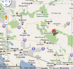
Arizona state map:
Hoshi's son, Mikito, runs a cattle ranch and manages and maintains the Arizona Wild Animal Park, where many species of wild animals range freely, or mostly freely, within the park, for the enjoyment of tourists to see the animals. Friends of the Park help pay for it and keep the animals in lands terraformed and planted with flora native to their normal habitat. The "A" in irrelevant. It is simply Google's way of saying here is Arizona.
The park and ranch are located northwest of Phoenix. Locate Phoenix near the center of the map, and then move up and left and find Wickenburg... just outside Wickenburg, in an area that is desert in our "real life" world, lies the Yonori Cattle Ranch and the Arizona Wild Animal Park, a tourist center for people to come and see the wild animals in natural-like habitats created for them to wander and graze and hunt, though the hunting is kept minimal by feeding the animals.
The park and ranch are located northwest of Phoenix. Locate Phoenix near the center of the map, and then move up and left and find Wickenburg... just outside Wickenburg, in an area that is desert in our "real life" world, lies the Yonori Cattle Ranch and the Arizona Wild Animal Park, a tourist center for people to come and see the wild animals in natural-like habitats created for them to wander and graze and hunt, though the hunting is kept minimal by feeding the animals.
Arizona map 2 (northwest of Phoenix):
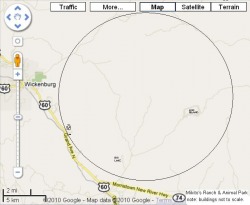
The circle is the tram road around the park, where tram-trains drive tourists around the park several times each day, with guides narrating what the people are seeing in the various areas.
Right-click on any of these maps to save it to your computer, and look at it with viewer software of your choice so that you may enlarge the map and see more detail.
Right-click on any of these maps to save it to your computer, and look at it with viewer software of your choice so that you may enlarge the map and see more detail.
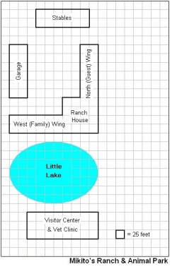
Arizona Animal Park
This drawing shows the divisions of the park, with layouts of roads, buildings, etc.
Right-click and download the map to your PC to view in any viewer, magnify and read the notes on the map.
Right-click and download the map to your PC to view in any viewer, magnify and read the notes on the map.

Mikito's Ranch house and Vet Clinic, west side, near entrance.
Mikito has two ranch houses in the Animal Park area, one on the west side and the other in the central area overlooking all four of the main park divisions. The floor plans are mostly the same, but Little Lake and the vet clinic are only on the west side.
The general layouts of these buildings match up to the floorplans shown below.
The general layouts of these buildings match up to the floorplans shown below.
Mikito's Ranch House, main building floor plan:
This is the floorplan of the main part of the ranch house. The two "wings" are shown in other drawings. Download the image and enlarge to view all the details and notes.

Mikito's Ranch House, family (west) wing floorplan:
This is the floorplan of the west wing. The north wing is similar, but rotated 90 degrees. The north wing differs in that there are only guest rooms, no master-suites for the owners.

Ribatii: John "Jack" Stone's mountaintop home.
Ribatii -- Japanese for "Liberty" -- is Jack Stone's mountaintop home in Arizona, overlooking the Arizona Animal Park.
In-game, Neko, Lynx and Tasha have been there, visiting.
In-game, Neko, Lynx and Tasha have been there, visiting.

Illinois Maps
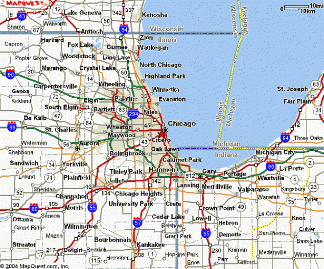
Chicago area
Our game is titled Solo Chicago and is set primarily in northern Illinois, specifically Chicagoland, which is the city of Chicago and its suburbs, as far north as the Illinois-Wisconsin state line, as far east as the Illinois-Indiana state line, as far south as Joliet and Kankakee, and as far west as Aurora and DeKalb... and sometimes somewhat beyond those limits. The following maps and floor plans are from or in this area.
Tia's home is in Lisle, which is near Wheaton in the map above
A fair part of our game stories take place in and around the Chicago area. Tia's primary home in the US is in Lisle, which is just south and east of Wheaton, which is called out in the map above. Below is an interactive Google map which you may enlarge and manipulate.
Interactive Google Map
of the Morton Arboretum area
Click on the map to activate its features.
- Click the "X" to get rid of the "Address" box.
- The arrows scroll the map window up, down, left or right. Or you may do the same by click and drag with your mouse pointer.
- The + and - (Plus and Minus) buttons enlarge or reduce map size, zooming in or out... if you have a third wheel on your mouse, it can do the same thing.
- The map starts in "Map" mode. Try the "Sat" and "Ter" (Satellite and Terrain) modes, too.
The map below shows a closer-in view of Chicago and its neighborhoods.

Chicago "Loop" and immediate surroundings:

Tia Tanaka's home, northwest of the Morton Arboretum
This is a fictional place that is, in the real world, a more well-to-do neighborhood in the village of Lisle, IL (west suburbs, about 30 miles from downtown Chicago). In our game, Tia's estate is located in this area as shown on the map below.

Tia Tanaka House, Lisle, IL
Shown below is the floor plan for Tia's home in Lisle, Illinois.

Japan Maps
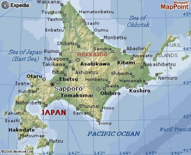
Hokkaido, northernmost island of Japan
Some of our game action takes place in Japan, notably in Japan's northernmost island...
Hokkaido (link opens wikipedia page in a new tab or window) is the northernmost island of Japan, formerly known as Ezo, Yezo, Yeso, or Yesso, is Japan's second largest island and the largest, northernmost of its 47 prefectural-level subdivisions. The Tsugaru Strait separates Hokkaidō from Honshū, although the two islands are connected by the underwater Seikan Tunnel. The largest city on Hokkaidō is its capital, Sapporo, which is also its only ordinance-designated city, a city designed by government ordinance. There is a wealth of information on Hokkaido, and the other islands of Japan, on Wikipedia.
Hokkaido (link opens wikipedia page in a new tab or window) is the northernmost island of Japan, formerly known as Ezo, Yezo, Yeso, or Yesso, is Japan's second largest island and the largest, northernmost of its 47 prefectural-level subdivisions. The Tsugaru Strait separates Hokkaidō from Honshū, although the two islands are connected by the underwater Seikan Tunnel. The largest city on Hokkaidō is its capital, Sapporo, which is also its only ordinance-designated city, a city designed by government ordinance. There is a wealth of information on Hokkaido, and the other islands of Japan, on Wikipedia.
Hokkaido: South end of the northernmost island
One of our game's primary NPCs (non-player characters), Hoshi, is from Hokkaido, specifically from the fictional mountain village of Yonori, which is near the city of Onuma, north of Hakodate. Hoshi's two aides, Aiyara and Boktu, are of the Ainu race (similar in appearance to American Indians).

South Hokkaido, a closer view
Right-click map to download to your PC and view it in a jpg viewer of your choice. Note that these images are snapshots and the arrows and zoom controls are not functional here. You may also go to google and search for Hokkaido map and view the island on interactive Google maps.
Hoshi's village of Yonori, and her home on Hokkaido, is in the Kameda district. Google maps do not show the fictional village, of course.
Hoshi's village of Yonori, and her home on Hokkaido, is in the Kameda district. Google maps do not show the fictional village, of course.

Kameda district
This map zooms in for a bit closer view of the Kameda District of Hokkaido's mountainous southern part of the island.

The Bay and City of Hakodate, Hokkaido, Japan
From the town of Yonori, Hakodate is the nearest large city after Onuma, and some of our game activities have taken place in that city. It is a relatively quick bus or train ride between the two cities... Onuma is in the mountains and Hokkaido is down at the sea.

Area north of Hakodate
I'm not sure why we grabbed this map, but here it is.

Kameda District, Onuma, Onuma Quasi-National Park
This is a map of the Kameda District area around Onuma.

Town of Yonori, Hokkaido, Japan
This is a mountain-side town on the island of Hokkaido... a fictional town and Hoshi's home.

Hoshi's house, Yonori, Hokkaido, Japan
This is a floorplan of Hoshi's home, a mountainside house in the town of Yonori, on the island of Hokkaido.

Hoshi's house, a closer view of a bedroom suite
This is the floorplan of a typical suite in Hoshi's home.

